Memory-Map

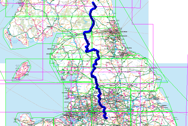
Pennine Way Route – .gpx

Pennine Way Route

Pennine Way Route gpx file is available on the Downloads page. This route was created using Memory Map on my laptop and then used in the field on my smartphone – read more about my backpacking tech here.

This English National Trail connects Edale to Kirk Yetholm crossing the backbone of the country, passing through a number of National Parks. Near Keld it also crosses Wainwright’s Coast to Coast path.

Fifty Years of the Pennine Way

Pennine Way Route

Free Downloads

I have a selection routes, in GPX format and a lightweight backpacking gear list  spread sheet available for free download – see here.

Loading gpx Files into Memory Map on the iPhone

Read my article – here – on how I keep my Memory Map files in Microsoft OneDrive so they are available on my iPhone.


This article is sponsored by Octagon Technology – suppliers of hosted secure email compatible with CJSM Secure eMail – Criminal Justice Secure eMail

Pennine Way Route – .gpx Read More »
Southern Upland Way- .gpx file

I have added a plot of the Southern Upland Way to my Download page – the file is the standard .gpx format so it is useable in a wide range of GPS units and applications. I am usiing it in Memory Map and on my iPhone.

There were some problems plotting the route on my 50k OS map – at the following locations – the route was not clear on the map.

  • Caldons Wood
  • Sanquhar
  • Wanlockhead
  • Sweetshaw Brae
  • Beatnock
  • Galashiels
  • Abbey St Bathans

If you use this route you will have to take care over those sections.

I plotted the route to skirt Glengaber Hill.

This is a walk I am planning to undertake in the summer of 2013. The plan at this time is to take fourteen days, carry lightweight camping gear and to stay in a mixture of campsites, wild camping and bed and breakfasts. Carrying food as required and resupplying along the route.

Southern Upland Way- .gpx file Read More »

Elgin Cathedral

We went to Elgin today – to see Elgin Cathedral. Diana had been there when she was six or seven and had been very impressed by it, so we were going back to have a look.

As we entered the town there was a sign saying it was an “Historic Cathedral Town” – and that was the the only sign we could see for the Cathedral. We parked and tried to find the Tourist Information – there was a sign for that and we followed it, but we could not find the Tourist Information. There were a number of information sign posts – showing where the post office, town centre and other things were but no Cathedral sign.

So out with the PDA, Memory-Map and the GPS unit – the cathedral was marked on the OS map and the GPS took us there. (See here for my mobile tech kit.)

There was sign for the cathedral which we found eventually, and if we had been coming in from the other side of the town we would have seen it – of course we would have seen it if we had given up, got the car and left Elgin to go to Aberdeen instead – as we were leaving the town!

Come Elgin council get your act together – it cannot be hard to put a few signs up – where the tourists can see them.

The Cathedral was impressive – we shall go back next year and have a good look round. The Biblical Gardens next door to the cathedral were excellent and well worth visiting Elgin for on there own.

Elgin Cathedral Read More »